
 HOME
 WAEC
 NECO
 07048281409

BEST EXPO RUNZ ASSISTANCE WEBSITE. NO.1 BEST DELIVERY OF EXAM RUNZ
100% GUARANTEE OF GETTING ANSWERS MIDNIGHT..IT’S OUR CULTURE, NO DOUBT
===================================
SECTION A: QUESTION ONE(1) IS COMPULSORY
(1)
===================================
SECTION B
PART I: ANSWER THREE(3) QUESTIONS FROM THIS PART
(2a)
(2b)
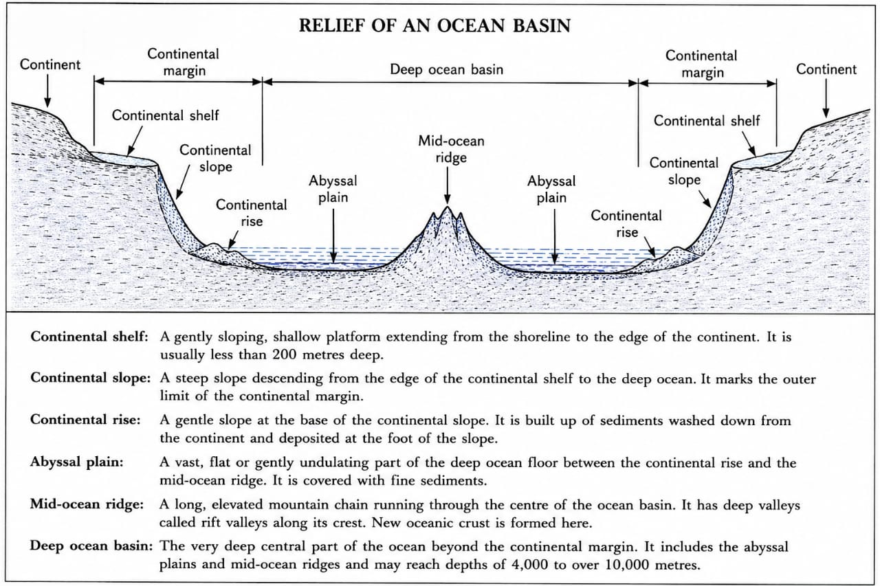
(i) Deep water: Deep natural harbours allow large ships to berth without constant dredging.
(ii) Sheltered harbour: Protection from strong winds, waves, and storms ensures the safe anchorage of ships.
(iii) Low tidal range and calm waters: Calm waters with moderate tidal conditions make loading, unloading, and navigation easier and safer.
(iv) Wide and unobstructed harbour entrance: A broad entrance free from rocks, sandbars, reefs, and other hazards allows ships to enter and leave the port safely.
===================================
(3ai)
In limestone (karst) regions, rainwater absorbs carbon dioxide from the air and soil to form a weak carbonic acid. This acidic water seeps through cracks and joints in the limestone and dissolves calcium carbonate, carrying it in solution as calcium bicarbonate. When the mineral-laden water drips from the roof of a cave, it loses carbon dioxide and deposits a small amount of calcium carbonate. Continuous deposition over many years builds an icicle-like feature hanging from the cave roof called a stalactite. As the remaining water falls to the cave floor, it also loses carbon dioxide and deposits calcium carbonate, gradually building an upward-growing mound called a stalagmite. Over time, a stalactite and stalagmite may join together to form a pillar (column).
(3aii)
In limestone (karst) regions, rainwater containing dissolved carbon dioxide forms weak carbonic acid, which seeps into joints and cracks in the limestone. The acid gradually dissolves the limestone, enlarging the cracks into underground cavities. As these cavities become larger, the roof may become too weak to support the overlying rock and collapses, forming a circular or funnel-shaped depression known as a sink hole. Where a surface stream flows into one of these enlarged openings and disappears underground to continue as an underground stream, the opening is called a swallow hole. Both landforms continue to enlarge through further solution of the limestone.
(3aiii)
Dykes and sills are minor intrusive igneous landforms formed when molten magma forces its way into cracks or between layers of existing rocks and cools before reaching the Earth’s surface. A dyke is formed when magma intrudes vertically or at a steep angle, cutting across existing rock layers. A sill is formed when magma intrudes horizontally between rock layers, running parallel to the bedding planes. After cooling and solidification, both form hard igneous rocks which often remain as ridges after the surrounding softer rocks have been eroded.
(3b)
(i) Thin, rocky, infertile soils with rapid drainage make crop cultivation difficult.
(ii) Scarcity of surface water because rivers and streams disappear underground through sink holes and swallow holes, making irrigation and livestock watering difficult.
===================================
(4a)
Environmental pollution is the contamination of the environment (air, water, and land) by harmful substances or wastes in quantities that are dangerous to living organisms and degrade the quality of the environment.
(4b)
(i) Industrial activities: Factories release smoke, toxic gases, chemicals, and untreated liquid wastes into the air, rivers, and land. These pollutants contaminate the environment and pose serious health risks to humans, animals, and plants.
(ii) Improper disposal of wastes: Dumping refuse, plastics, sewage, and other wastes indiscriminately on land or into water bodies pollutes the soil and water. It also blocks drainage channels, causes flooding, and creates breeding grounds for disease-causing organisms.
(iii) Agricultural activities: The excessive use of fertilizers, pesticides, herbicides, and other agrochemicals contaminates the soil and nearby rivers through runoff. Livestock wastes also contribute to land and water pollution.
(iv) Burning of fossil fuels and bush burning: The burning of petrol, diesel, coal, firewood, and bushes releases smoke, carbon dioxide, carbon monoxide, sulphur dioxide, and other harmful gases into the atmosphere. These pollutants cause air pollution, respiratory diseases, acid rain, and global warming.
(4c)
(i) Enforce environmental laws and regulations: Governments should enforce strict environmental laws by monitoring industries, vehicles, and individuals, and imposing penalties on those who pollute the environment. This helps reduce the release of harmful pollutants.
(ii) Proper waste management: Refuse and sewage should be collected regularly and disposed of safely through sanitary landfills, recycling, composting, and proper treatment. This prevents pollution of land, air, and water.
(iii) Afforestation and environmental education: More trees should be planted to improve air quality and reduce the effects of pollution. People should also be educated on proper environmental practices such as avoiding indiscriminate waste disposal, reducing bush burning, and protecting natural resources.
===================================
PART II: ANSWER ONE(1) QUESTION FROM THIS PART
(5a)
Geo-referencing is the process of assigning real-world geographic coordinates (such as latitude and longitude) to a map, image, or dataset so that it can be accurately located and used within a Geographic Information System (GIS).
(5b)
(i) Spatial data describe the location, shape, size, and position of geographic features, whereas attribute data describe the characteristics or properties of those features.
(ii) Spatial data are displayed graphically on maps as points, lines, and polygons, whereas attribute data are displayed as records in tables or databases linked to the mapped features.
(iii) Spatial data are used to determine the spatial relationship and distribution of features, whereas attribute data are used to provide descriptive information about those features.
(5c)
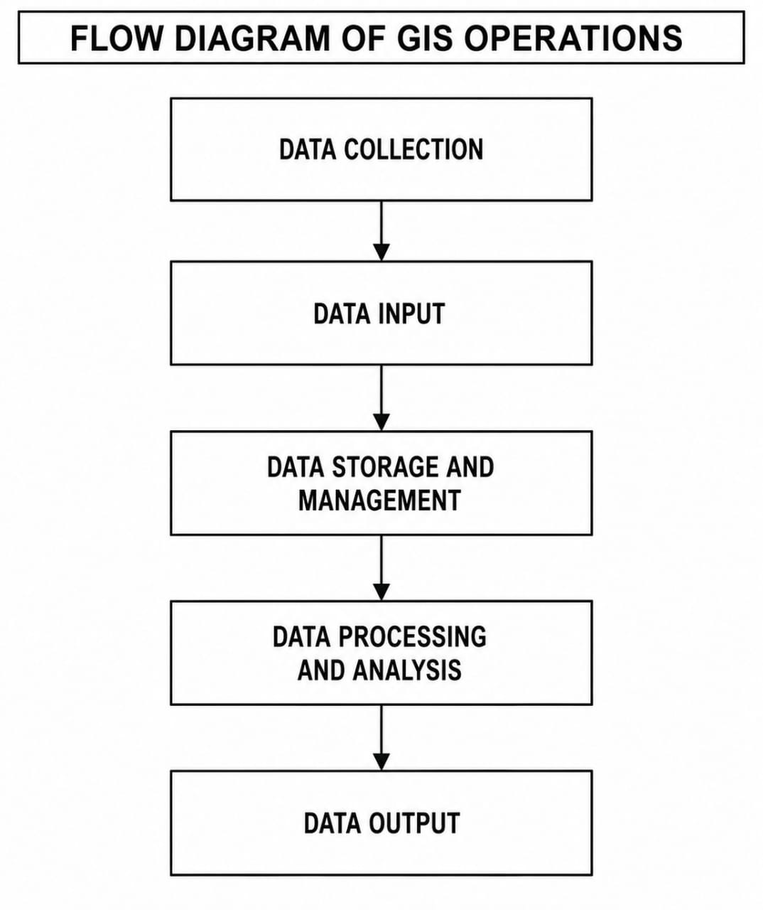
(i) Data Collection: This is the first stage where geographic data are obtained from sources such as field surveys, satellite images, aerial photographs, GPS, maps, and remote sensing.
(ii) Data Input: The collected data are entered into the GIS through digitising, scanning, keyboard entry, or importing digital files into the computer.
(iii) Data Storage and Management: The data are organised, stored, updated, and managed in a database to ensure they can be easily retrieved, edited, and maintained.
(iv) Data Processing and Analysis: The stored data are processed and analysed using GIS tools to identify patterns, relationships, distances, overlays, and spatial distributions for decision-making.
(v) Data Output: The processed information is presented as maps, tables, charts, graphs, or reports, enabling users to interpret the results and make informed decisions.
===================================
(6a)
(i) High cost of GIS equipment and software: GIS requires expensive computers, GPS devices, scanners, plotters, satellite imagery, and licensed software. The high cost makes it difficult for many organisations and institutions in Nigeria to acquire and maintain GIS facilities.
(ii) Inadequate skilled personnel: There is a shortage of trained GIS professionals and technicians in Nigeria. This limits the effective operation, maintenance, and application of GIS in many sectors.
(iii) Poor availability and quality of spatial data: Accurate and up-to-date geographic data are often lacking. Incomplete, outdated, or unreliable data reduce the accuracy and effectiveness of GIS analyses and decision-making.
(iv) Poor electricity supply and inadequate infrastructure: Frequent power outages and poor internet connectivity disrupt GIS operations, delay data processing, and increase the cost of maintaining GIS facilities.
(6b)
(i) Maps
(ii) Tables
(iii) Charts
(iv) Reports
(6c)
(i) Land use and urban planning.
(ii) Environmental monitoring and management.
(iii) Disaster and emergency management.
(iv) Transportation and route planning.
===================================
COMPLETED….We Remain Your Favourite Site.
Ensure You Subscribe For Your Next Paper
===================================
Leave a Reply